Downtown Visioning Plans & Studies
1994 Downtown Improvement Plan
|
1996 DIP Phase 1 Design Development Report
|
2004 Downtown Improvement Plan Update
|
2017 Downtown Action Plan
|
2012 Cal Poly Downtown Improvement Plan (Draft/Unofficial)
Downtown District Overlay - 2040 General Plan
Proposed Downtown District Policy (Draft - August 2019)
|
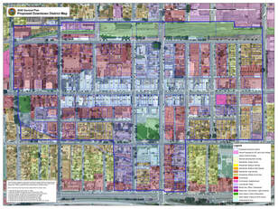
Downtown District Overlay Map
|
Política Propuesta para el Distrito del Centro - Agosto de 2019 (Borrador)
|
Frequently Asked Questions about the Downtown District Overlay
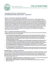
What is the new Downtown District, and what is an overlay?
The 'new' Downtown District overlay was adopted as part of the 2040 General Plan, however, the overlay actually isn’t new at all. The boundary is based on historical precedent (both official documents and common knowledge) identifying the central core of town; covering the majority of the area between the Historic Downtown entry monuments at 7th and 12th Streets, and Harvard Blvd. to the railroad tracks.
An overlay is a planning tool used by cities to induce compatible residential infill and mixed-use development (reinforcing existing architectural character), upgrade infrastructure (streets, utilities, parking, etc) and improve conditions for pedestrians (safer crossings, pocket parks, etc) without altering the underlying land use designation.
What is the difference between an overlay district and underlying land use designations?
An overlay district works just like it sounds – regulatory language is laid over the existing land use. The two are intended to work together to provide increased optional provisions such as allowed uses, development standards and design criteria. Existing underlying land use designations do not change when an overlay is applied.
Is the Downtown District (DD) the same thing as the Business Improvement District (BID)?
No – they are totally separate initiatives of different City departments. The new DD overlay is a long-range planning tool that is part of the general blueprint for the growth of the City. The BID is a short-term administrative tool that assesses opted-in member properties for site-specific improvements such as lighting, signage, accessibility provisions, paving, etc., and encompasses a much smaller area.
Does the Downtown District overlay result in my property being assessed or taxed?
No. The Downtown District provides a new General Plan land use designation only.
What are the potential impacts to residential and/or commercial-zoned properties within the Downtown District overlay? Is the city going to take away my home or business?
No existing development will be deemed non-conforming or illegal by the overlay. All the overlay does is provide an enhanced spectrum of optional development provisions in exchange for providing affordable housing and/or improving public infrastructure. Context-based Design Guidelines are also being developed to ensure compatibility with existing architectural character.
Are there any additional limitations to what I am allowed to do on my site?
No. The overlay is an optional incentive-based regulatory tool for compatible infill development.
Why did the City create the Downtown District?
California state legislators passed or have proposed several ambitious housing and transit-oriented bills (SB827, SB50, etc.) that will require cities to effectively address the state housing and transit crises. Staff is proactively taking steps to better position land use designations and related local legislation to be ready to meet state requirements when they come into effect. The boundary area is intended to contain land with maximal infill potential for compatible development (mainly housing) on parking lots, vacant lots, and under-utilized or partially developed lots. Additionally, the increased development flexibility provided by the overlay will hopefully encourage the continued revitalization of the downtown area.
What sort of regulations and policies should a developer or property owner expect to see with projects in the Downtown District?
The Downtown District overlay policy sets new standards and processes to ensure compatibility and protect the downtown core area and its historic design character. Staff will prepare the following with public input for Planning Commission and City Council review and approval:
- Preferred Use Provisions – a set of permitted uses intended to prioritize housing and compatible small-scale commercial (primarily office & retail).
- Development Standards – new regulations focusing on compatibility between abutting transitional uses (set-backs, height step-down, lot coverage, etc.)
- Infrastructure Improvements – in-lieu fee structure as mandatory provisions for developments taking advantage of new overlay incentives. Fees will pay for the following:
- District Parking. Strategies and programs to meet parking demand through creative means (such as joint-use agreements, district parking, shared use, etc – the downtown has over 1,500 surface parking spaces that are very underutilized).
- Downtown Infrastructure. Other infrastructure will be improved (paving, parks, sidewalks, etc.).
- Pedestrian Safety and Security. Strategies and programs to protect the pedestrian – related to lighting, signage, accessibility and ground-level transparency.
- Public Space. Enhanced and expanded small-scale public spaces (such as Green/Mill Alleys, Paseos, etc.)
